ΑΝΑΚΟΙΝΩΣΗ-ΕΚΤΙΜΗΣΗ ΓΙΑ ΤΗ ΣΕΙΣΜΙΚΗ ΔΡΑΣΤΗΡΙΟΤΗΤΑ ΤΗΣ ΤΑΦΡΟΥ ΤΟΥ ΒΟΡΕΙΟΥ ΑΙΓΑΙΟΥ
Ο σημερινός σεισμός (Σάββατο μεσημέρι 24/5/2014) μεγέθους 6.5, το επίκεντρο του οποίου εντοπίζεται στο θαλάσσιο χώρο μεταξύ Σαμοθράκης, Ίμβρου και Λήμνου (40.30 Ν – 25.40 Ε ), πλησιέστερα στη Σαμοθράκη ανήκει στη γνωστή και αρκετά καλά μελετημένη ζώνη των ενεργών ρηγμάτων της Τάφρου του Βορείου Αιγαίου, η οποία αποτελεί προέκταση του μεγάλου ρήγματος της Βόρειας Ανατολίας. Τυπικό ρήγμα οριζόντιας μετατόπισης, δεξιόστροφο, Βορειανατολικής- Νοτιοδυτικής Διεύθυνσης, όπως προκύπτει από το μηχανισμό γένεσης της Αμερικανικής Γεωλογικής Εταιρείας.
Στη βάση δεδομένων GreDaSS, της Ερευνητικής Ομάδας Γεωλογίας των Σεισμών του Τμήματος Γεωλογίας του Α.Π.Θ., σε συνεργασία με το Πανεπιστήμιο της Ferrara (Ιταλία) και του Γεωφυσικού Ινστιτούτου της Ρώμης (INGV), η οποία δημιουργήθηκε με τις προδιαγραφές του ευρωπαϊκού προγράμματος SHARE (για την ομογενοποίηση όλων των ευρωπαϊκών – μεσογειακών σεισμολογικών δεδομένων), εμφανίζονται τα μεγάλα ρήγματα ως μονάδες για την εκτίμηση της Σεισμικής Επικινδυνότητας και ως μεμονωμένες δομές που ενεργοποιήθηκαν σε προηγούμενους σεισμούς. Στη Βάση εκτιμώνται και αναλύονται ΟΛΑ τα μέχρι σήμερα επιστημονικά δεδομένα, ενώ η Δυναμικότητα τους είναι της τάξης αναμενόμενου Μεγέθους Σεισμού 6,5 έως 7,5. Στην συγκεκριμένη περιοχή υπήρχε κενό από ενεργά ρήγματα που να είχαν δραστηριοποιηθεί από πρόσφατους ιστορικούς σεισμούς. Γενικά τα Ρήγματα της Τάφρου του Β. Αιγαίου αν και συνδέονται με ισχυρούς σεισμούς δεν αποτελούν σημαντική σεισμική απειλή για τις κατοικημένες περιοχές της Βορείου Ελλάδος και των νησιών του Βορείου Αιγαίου, γιατί εντοπίζονται σε υποθαλάσσιες περιοχές μακριά από δομημένες περιοχές.
Ως επιφανειακός σεισμός (5-10 km) της 24ης Μαΐου θα συνοδευτεί από μετασεισμούς, ενώ η δυναμικότητα και προϊστορία της ενεργοποίησης των ρηγμάτων της Τάφρου δεν αποκλείει τη συνέχιση της σεισμικής δραστηριότητας.
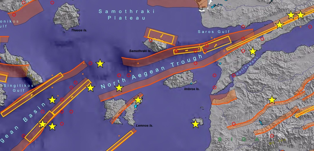
Απόσπασμα από τον χάρτη ενεργών ρηγμάτων της βάσης δεδομένων GreDaSS, όπου φαίνονται οι χαρτογραφημένες ενεργές ρηξιγενείς ζώνες στο χώρο Λήμνου - Σαμοθράκης - Ίμβρου (κόκκινες περιοχές). Οι κίτρινες περιοχές δείχνουν τα ρήγματα των ζωνών αυτών που δραστηριοποιηήθηκαν σε προηγούμενους σεισμούς. Είναι φανερό από το σχήμα ότι ο σεισμός της 24ης Μαΐου 2014 συνέβη σε τμήμα το οποίο δεν είχε δραστηριοποιηθεί στο παρελθόν. Τα κίτρινα άστρα δείχνουν τα επίκεντρα σεισμών με μέγεθος >7, οι μεγάλοι κύκλοι με μέγεθος 6-7 και οι μικροί με μέγεθος 5,5-6 για το διάστημα 550 π.Χ. - 2010.
Χρήσιμοι σύνδεσμοι
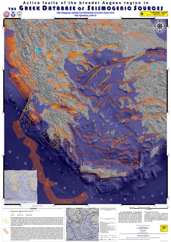
- Ο χάρτης ενεργών ρηγμάτων του Ελληνικού χώρου.
- Η βάση δεδομένων GreDaSS.
- Μία πρόσφατη εργασία για τα ενεργά ρήγματα στο ΒΑ Αιγαίο (Chatzipetros et al., 2013).
- Μία εργασία για τη βάση GreDaSS και τα ενεργά ρήγματα του Βόρειου Ελληνικού χώρου (Caputo et al., 2012).


 RSS Feed
